Earth's Formation by Meteor Impact

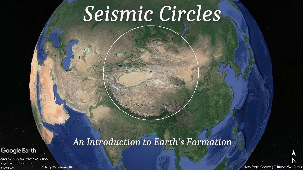
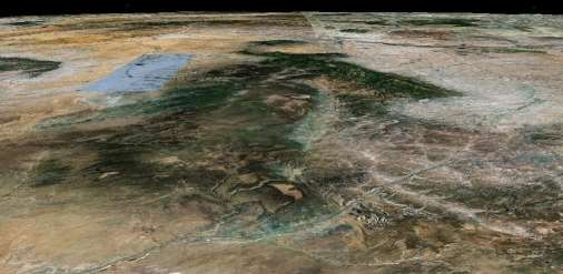
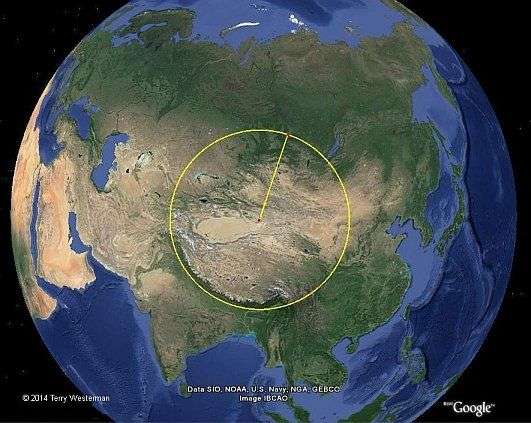
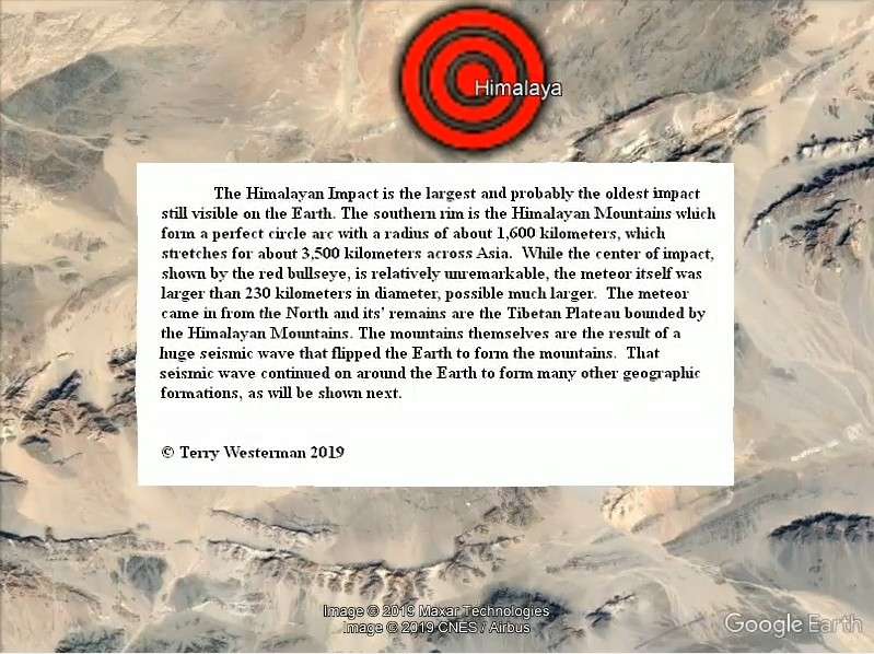
TheHimalayan Mountainsform part of a perfect circle, the results of the seismic wave from a meteor impact in the center of Asia. The meteor was probably larger than 230 miles (370 km) in diameter. The Tibetan Plateau is what remains of it.


Introduction

This is about the meteors, asteroids and comets that bombarded the Earth over the last billion years or so, how those impacts created our geography, and then how man has used those land forms. 


What drove me on this research is the increasing exactness in which these discoveries were made.

As a child, my family would take excursions in the car, to see the country and what was there. To keep me occupied, my Mother would give me the map, and she showed me how the different lines and symbols meant different things. From that, I learned to read and understand the maps, and this set me on a course of my life that I would read and collect all the maps that I could find of the area where I was, because they gave me a better understanding of the world around me.

In my mid 20's I was living in the State of Oregon and I came across a map of Oregon that was hand drawn, but done so to a very high degree. As I studied it, I found what looked like a large meteor crater in the southeastern part of the State. Comparing that to other maps I had, I could only get rough 'Maybes' from them for confirmations of the idea. Then one day I ran into a much older man, a professional geologist (whose name is long ago gone), who I thought would have some insight into this, and I queried him on the idea. His response was that there were no meteor craters on the Earth, and the reason it looked like one to me was because the map was hand drawn.

That didn't answer my curiosity in the way I wanted to hear, but at the time there were no other sources of information available. And it stayed that way until Google Earth came along. Using that I found my childhood home, where I kissed my high school sweetheart, and a number of other such things, and then I remembered that map! "Is that possible?", I said to myself. So I went to Oregon on Google Earth and looked, and there it was, plain as day. And then - there was another one.... and another and soon I had circles that described nearly every geographic feature of those high desert plains

Some of the many meteor impacts in Oregon State.

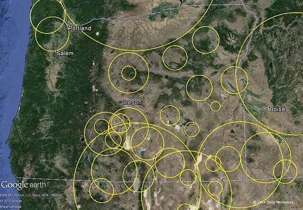
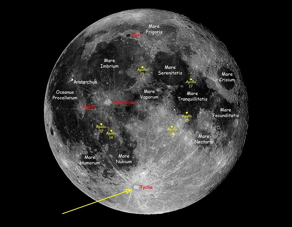
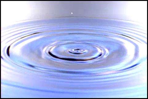
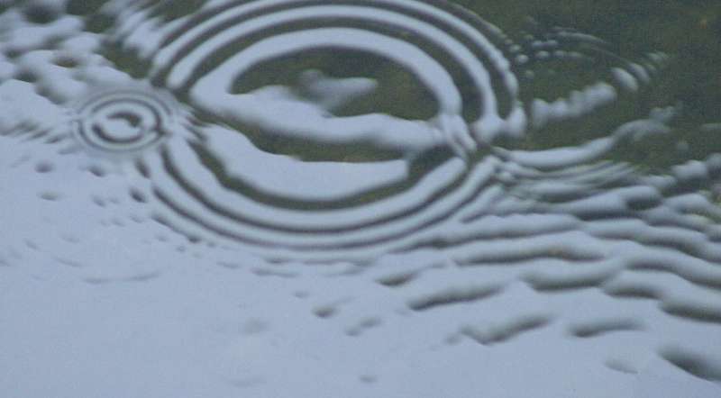
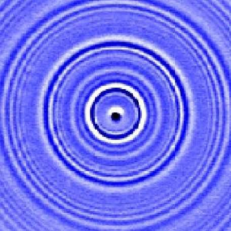
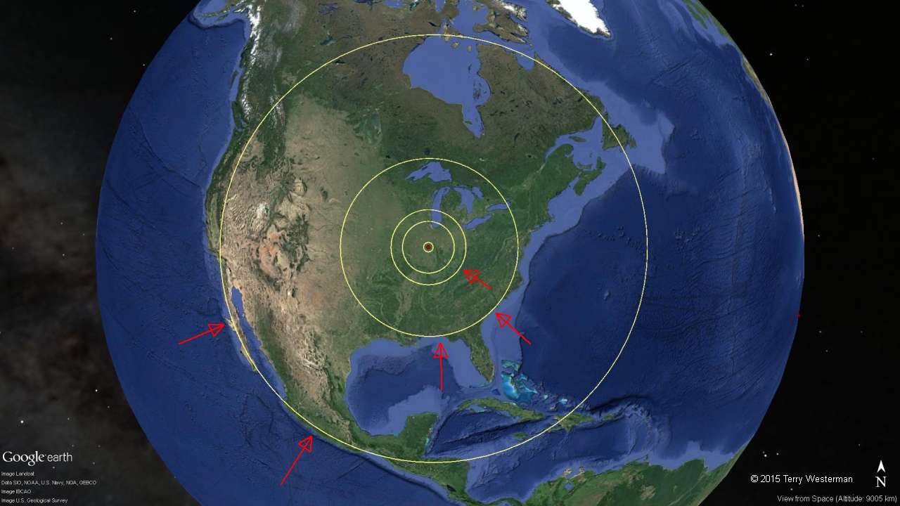
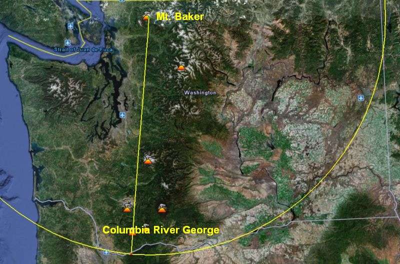
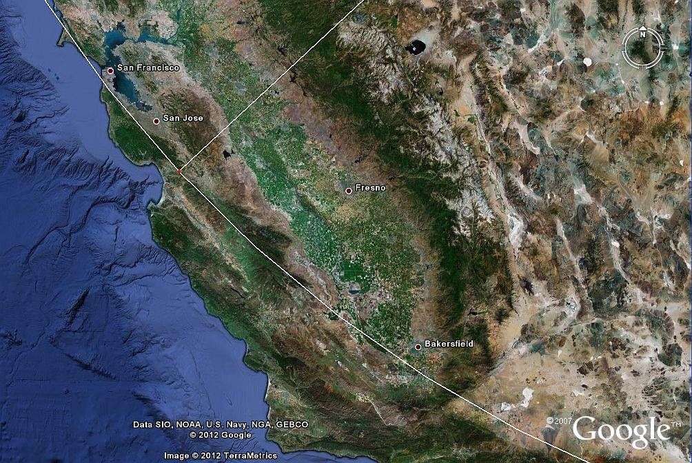
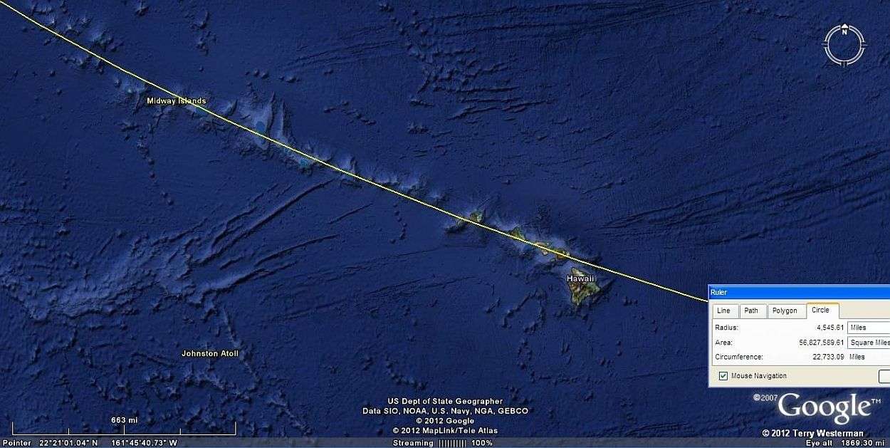
That started a journey of discovery. From there I started to see how the land was formed, over and over again there were circles, just like on the Moon. Yes, they were eroded, covered with vegetation or farmed over for many years, even centuries, but the main features were there. These impact circles formed the mountains, the rivers, the coastlines and more, all over the world. Then after a time, I started to see that many of these impacts left not just one circle, but a series of circles, concentric circles around them, seismic circles. And, I was increasingly amazed at how these circles expanded over vast distances, forming the geography of places hundreds and sometimes thousands of miles away from the impact.

Then I started to see how man has been using the land forms created by these seismic circles, and so the research continues.

While much of this work is here simply to demonstrate why our world is as it is, it is also here to provide evidence of the impacts, and how the Earth was formed.

Hopefully some will use these studies as a template, and begin a search for discoveries of your own. There is still much to be done. And when you see those geographical features falling exactly on that perfect circle, you will say as I did "No Way!", "Are you serious?", "That's incredible!" Then by studying more of the evidence you will see that, Yes, it is serious. Yes, it is incredible. Our world did came to be by Catastrophic Impact, and the remains of those impacts, those Seismic Circles, are what formed the geography we have today.


Forward
This work is based on the works of:
Google Earth
NASA - National Aeronautics and Space Administration
Cnes/Spot Image - Centre National d'Etudes Spatiales the French government space agency
Data SIO    - the Scripps Institution of Oceanography, University of California San Diego
NOAA - National Oceanic and Atmospheric Administration
U. S. Navy
NGA - National Geospatial-Intelligence Agency
GEBCO - General Bathymetric Chart of the Oceans
U. S. Department of State Geographer
U. S. Geological Survey
Geo Eye
MapLink
Tele Atlas
Terrametrics
GeoBasis -DE/BKG
Europa Technologies
GIS Innovatsia
ORION-ME
DigitalGlobe
Basarsoft
European Space Imaging
Province of British Columbia
Mapabc.org
Whereis
Sensis Pty Ltd
Inav/Geosistemas SRL
ZENRIN
SK Energy
Kingway Ltd.
INEGI
Texas Orthoimagery Program
USDA Farm Services Agency
GIS Innovatsia
Mapabc.org
And other organizations as noted on the images.
These people have put together the best of the imagery of our Earth so that we can see and study our world in a way that was not possible before.
They have created the tools which allow us a new understanding of the world we live in.


The many meteor impacts on the far side of the Moon

The Far Side of the Moon
     If the Earth did not have its' water and atmosphere to erode the surface, and the plant life to cover it up, the Earth would look very similar to the far side of the Moon.

      Until recently all of our observations of the Earth were made on the ground. Geographers measure the surface of the Earth and plot their findings on paper, drawing maps of all sorts. While these maps are necessary and useful, using them as a basis for the Earth sciences today is problematic. Maps are drawings of what we understand to be there, rather than the real thing, and the various projections used to draw the surface of a nearly spherical Earth on a flat sheet of paper distorts the dimensions, or cuts the geography into pieces, leading sometimes to questionable conclusions.

      Then came aerial surveys, photography from five or six miles up. From these are drawn maps of excellent quality which are good for property analysis, roads and land use planning. But even with these we cannot see enough of our planet to get a good look at it, as many of the features of our Earth are 10s or 100s or 1,000s of miles across.

         Geologists searching the ground use microscopes, gas chromatography, radiation, spectral analysis or other means to analyze what they found on or near the surface. Sometimes they find shatter cones, microscopic diamonds or iridium layers and this is evidence that a meteor impacted the Earth there. This evidence is then compared with other findings to confirm the impact.


       This seems to work for smaller impacts, but the larger ones are beyond the scale of these methods. To examine meteor impact of ten miles in diameter, which is very small in cosmic terms, on these basis would be a daunting task, let alone the problem of actually recognizing the impact from the ground or even from aerial surveys.

      To understand our Earth, we need to see it as the sphere that it is, and we need to be able to see it at distances where the geographic features can be seen in their entirety, and in relation to the surrounding area. And, we need views that are as free of clouds as possible. Satellite imagery is the only way to do this.

      Google Earth has made this possible. They have assembled the imagery of a myriad of organizations and companies, which have been filled with an untold number of highly skilled scientific people, all with the quest to understand our Earth better. They have provided us with a tool from which we can see our entire planet in its' entirety, down to fine geographic detail. With this new tool comes new understandings of our Earth.

Meteor Impacts through Central America      
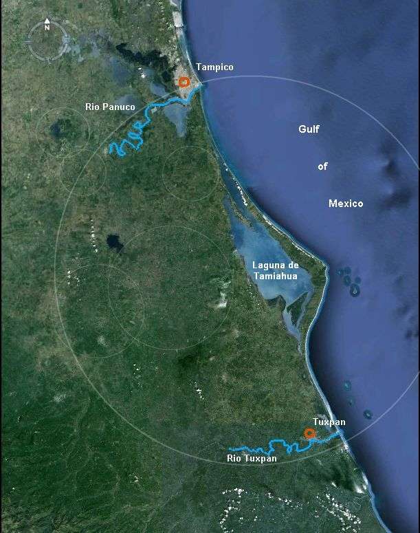
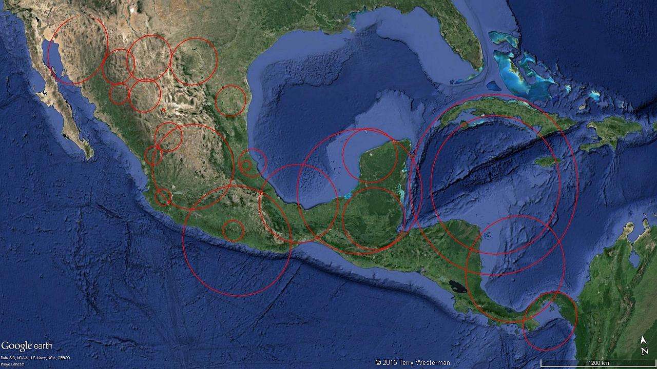
The above image of Central America shows numerous circles, each one encompassing a meteor impact site. If you study these circles, the impacts should become apparent. These are the most obvious, others could be noted.This image is linked to a larger image for more detail. The Earth is covered with impacts such as these, some larger, many smaller. Once your eye becomes tuned to seeing them, you will find them everywhere.

Meteor impacts in India
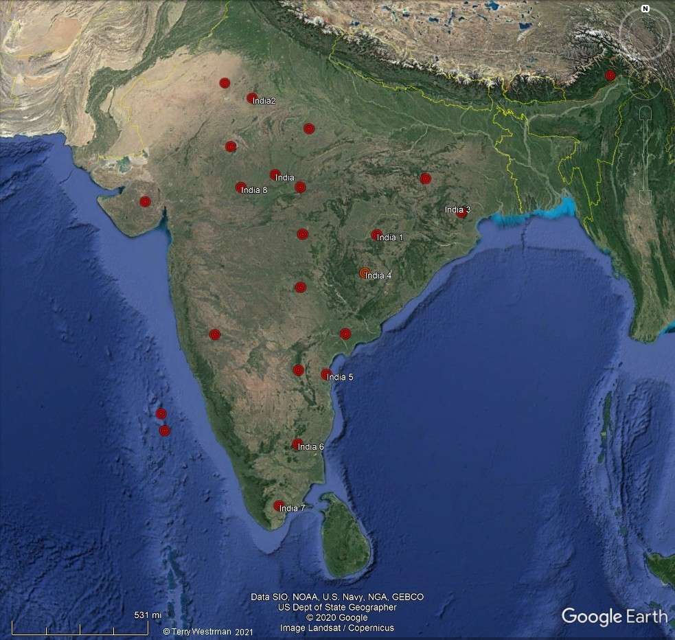
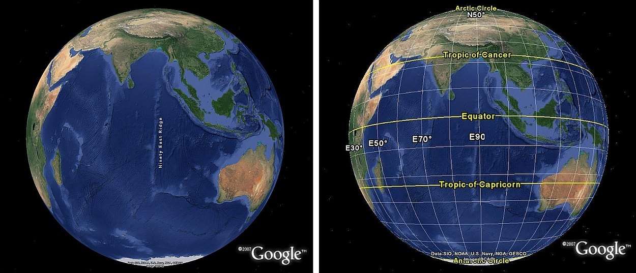
     India was hit by many meteors The red spots in the image above denote the center of impact for some of the larger ones. Click on the image to investigate this farther.
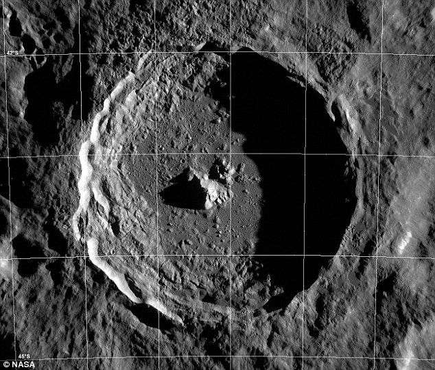
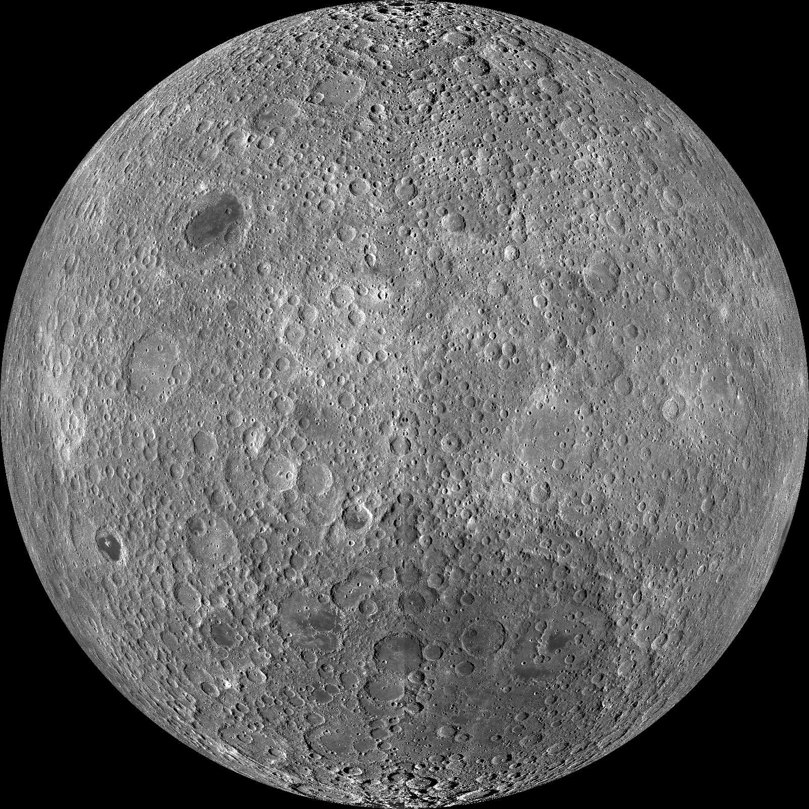
 

The Earth was built layer by layer, meteor by meteor.      Our Earth was built over billions of years by the bombardment of an untold number of asteroids, meteors, comets, and extra terrestrial objects of all kinds, shapes and sizes, just like the Moon, Mars, Venus and Mercury were. These impacts created the form of our Earth, building it up layer by layer, one impact after another. Gravity then pulls the Earth into a nearly perfect sphere, and the rotation of the Earth causes a bit of a bulge around the Equator. Then, with erosion from the atmosphere, vegetation covering things over, glaciation, volcanoes and other natural forces, we have what we have today.

      While very small impacts may have been obliterated by time and erosion, the larger impacts left substantial marks and many times in grandiose design. In fact, these impacts gave us our geography. They are the valley that the river flows in, the mountain top Skyline Drive that gives us those exhilarating views. They are the coast lines, the national parks and the dirt you walk over every day. The formations left from these impacts are where towns and cities where built, and many of them are our political boundaries. Often they define the way we plant our crops, where we build our roads and reservoirs, and where we find the minerals that enrich our lives. These impacts placed the volcanoes and the fault lines where earthquakes occur, and they shaped the continents.

      This new evidence demonstrates that the surface of the Earth has remained relatively unchanged for a long, long time. Where it was thought that most of the formations of Earth were formed slowly over millions of years of time, in fact most of the formations on the Earth came to be by catastrophic impact. These impacts then caused seismic shock waves which expanded across the Earth in the form of concentric circles similar to a stone thrown into a still pond of water. While our atmosphere and time have eroded these forms, the remains of these seismic waves are precise and still clearly visible today. Where it was thought that the mountains were raised by continents colliding, and the rivers formed by erosion
over millions of years, it can be shown now that these things happened in a heartbeat by these seismic circles traveling across our planet at tremendous speeds.

     While it is certain that the crust of the Earth is shifting in places, which is the cause of earthquakes, this is something quite different than the idea of Pangaea and continental plates floating around. These geographic circles provide evidence that contradicts those ideas. Many of these seismic circles are hundreds and sometimes thousands of miles in radius. Some of them span continents, a few circle the globe and sometimes the concentric circles from individual impacts are visible on six continents, Antarctica being too ice covered for analysis. Had the continents been drifting, then parts of these circles would be moved. Yet the circles are intact.

     Most of the impacts that are discussed here are huge, but the principles that are shown apply to impacts of all sizes. By understanding them, the reason why the local river flows where it does will become evident. Why towns and cities were built where they were, and where minerals are found will become more clear. The soil sciences, land use planning, geology and Earth Sciences generally will have new insights to advance their knowledge base.

     This treatise is not intended to be all inclusive of all impacts. That would not be possible. It is intended to demonstrate the major impacts of a variety of types and how they formed the Earth. Nor is this intended to be the last say in the formation of the Earth. To the contrary, it is intended to act as a guide to further research, to help us form a new understanding of our home planet, how it came to be, and why it is as it is. What you see here is just a beginning. The more we look, the more we see. With these new tools, a whole new world awaits.


The Beginning

     The idea of an impact, is typically a crater like we see on the Moon. This image of Tycho Crater on the Moon is generally of how we think of them, as a depressed area with a circle of steep walls surrounding it, and a central peak. This is only the case here on Earth sometimes.

     Whether or not an impact raised a rim when it was formed is dependent on a number of factors, such as the size of the impactor, the difference in density between the earth and the impactor, relative speeds, and the terrain where the impact occurs (mountainous, plains, water). Also the stronger gravity is, the less steep the resulting walls can be, and the less high. A peak in the center is also a rarity. As the gravity of the Earth is six times that of the Moon, the impactors come in faster, and hit harder. What is left is usually smashed to bits and scattered in all directions, or buried deeply in the Earth.

     On the Earth today we find mainly remnants of the impacts due to erosion from our atmosphere over time. However many parts of the circles are still visible as these impacts formed most of the geographic features of our planet. These remnants fall in precise circles around the center of the impact.

     In the largest majority of impacts, the exact center is not much to speak of. This is because the meteor either blew itself out in all directions, or buried itself under the surface and the reverberating shock waves covered it over and the following erosion left nothing much to see. Sometimes the center may be slightly raised or lower than the surrounding area as a result of the oscillations that follow the impact, and it is not unusual to find a lake there, or if the area is higher, buildings such as farm houses and barns. These are not usually at the exact center because of the angle of impact, meteors rarely come in straight down. This effect can be seen in the image to the right of Tycho Crater, where the center peak is slightly to the left of center.

Tycho Crater, on the Moon
Tycho Crater, the Moon

    The actual impact site, the center, may be round or deformed depending on many variables. What was the shape of the object? Was it round, or perhaps some other shape. How did it hit? Straight down or at an angle? Was it a hard rock asteroid, or a dust ball comet? There are many variables, but more often than not, the center is flat, perhaps a little higher or lower than the surrounding area, but generally flat. On some occasions the impact may raise a center peak, or make a deep impression, but most often the center is not much different than the surrounding area, as the impact blasts everything flat. These level areas are then excellent areas for towns and cities to be built, such as Mexico City, Tokyo or Moscow.

      In the image at right, the Ebano Impact, is on the northwestern border of the State of Veracruz with San Luis Potosi State, Mexico. This impact is on the eastern coastal plane of Mexico. The soil there being relatively soft and wet was easy to penetrate deeply with a high speed, hard asteroid. The asteroid itself ended up deep underground, leaving the surface as a depression where the lake formed, with a raised center area, and low hills surrounding it.

Ebano meteor impact, Veracruz, San Luis Potosi border, Mexico
The Ebano Impact site, on the border of Veracruz and San Luis Potosi States in Mexico. The 'crater' is about 6 miles (9.5 kilometers) East to West.

South of Norfolk, Nebraska numerous impacts are visable.

     Often times the object may simply go splat, blowing the material of its making out across the Earth in all directions, and leaving little evidence of its existence other than a few inches of soil. These impacts would likely be made up of loosely packed meteors. Gravity on meteors in outer space is minuscule in comparison to the Earth. Therefore the meteor may be nothing more than a dust ball that just adds a bit of soil to the Earth when it hits.

     The image at left is of an area south of
Norfolk, Nebraska. A first look seems to show nothing but almost flat farm lands. However if you study the image, the shapes of numerous impacts will start to form.  Click on the image for more on this.

       Often the impact site is best described by a change in vegetation patterns, this due to different soil types from one impact to the next. These patterns can often be seen only from high above. Those that study the various soil types could benefit from a knowledge of  the limits of each type, as an aid to agriculture, land use planning and other sciences that base decisions on soil types and their properties.

       There are many kinds of impacts. When we look at them we must consider what the object must have been. On one extreme, it may have been formed from a solar flare that blew heavy metals out into space at tremendous speeds. These metals fused together by solar heat, and then tempered by the near zero degrees Kelvin of the deepest expanses of space, could be the hardest material imaginable. This type of object at incredible velocities would be like a bullet into the Earth, penetrating deeply leaving only a minimum crater, but perhaps sending out a shock wave that circles the impact site at hundreds of miles distance.

     With such an impact, the hole in the Earth could form a volcano. The Craters of the Moon National Monument, pictured to the right, was such an impact. It was hit about 15,000 years ago and occasionally spews lava. In time this is likely to grow to a volcanic peak

Craters of the Moon Impact shows lava flows from the puncture of the Earth.

Craters of the Moon National Monument.

     This impact was one of the hard, high velocity impacts that punched a hole in the Earth, from which the lava flowed on a number of occasions.


The Tamiahua Impact, Veracruz, Mexico.


      The shock waves may form a circular rim of hills, or they form valleys lower than the surrounding areas. Hills and valleys may appear on the same circle, this is because it depends on what the wave is moving through. If the wave moves through a hard rock area, it may uplift the rock to form hills or mountains. If the wave moves through a softer area, it may just shake up the ground. This softer area leads to erosion and rivers then form there. This is why many of the rivers flow where they do, and why many lakes, mountains and coastlines are where they are, and shaped as they are.

        This is the case for the Tamiahua impact site on the Gulf Coast of Mexico, pictured left, where the Rio Panuco defines the northwest edge, and the Rio Tuxpan defines the southern edge. An examination of the image at left will show other smaller impacts, some of them are marked, most of them are not.

      As each impact is marked, the formation of the land becomes more and more organized, so that the majority of land forms can be ascribed to one or more impacts. By defining the land this way, then the effects of the various other geological forces can be more easily recognized and understood.

     Since most impacts do not leave craters, it is more accurate to call these Impact Sites.


Full Moon labeled, Tycho Crater at the arrow


     They could come from a planetary sized object that was somehow torn apart to form asteroids such as in the asteroid belt between Mars and Jupiter. In this case they could have densities similar to that of the Earth.
     Sometimes they may explode when they hit, where pieces fly off in all directions, like throwing a piece of dried dirt against a concrete wall. This is the case of the Tycho Crater on the Moon, shown in the image at left, bottom center of the Moon.

El Perdido rayed Impact site, Mexico

It is also the form of the impact at El Perdido, Mexico that blasted rays over half the country.


      Asteroids coming in at various angles, speeds and densities combine to form our geography. The image to the right of the Eye of the Sahara is an interesting assemblage of impacts. It is in Mauritania in the western Sahara Desert in Africa

     On the other extreme a comet could have been roaming the galaxy for billions of years collecting particles bit by bit and slowly growing to something perhaps a hundred miles across or more. However, if gravity is proportional to mass, then even if the comet was 100 miles in diameter, the gravity of it would be infinitesimal compared to the gravity of Earth. Considering this, the comet would then be so loosely packed that only the light of the sun would be enough to blow material from the surface, and that would form the tail of the comets we see in the sky.

    Many of the impactors that hit the Earth were these giant dust balls. This is not to discount their significance because some of them still contained enough material to shape the continents and form the mountains. When they hit a large percentage of the material of their making is blasted out in all directions to form a new layer on the Earth. The hit still produces the circular shock waves which reform our Earth. In the center, the comet collapses and depending on several variables, the center may end up higher or lower than the surrounding terrain.

The Eye of the Sahara

The Eye of the Sahara 

The Southwestern U.S. id dominated by the Navajo Meteor Impact

The Center of Impact at the Navajo Impact Site, Arizona-New Mexico.


    Oddly enough, when these impact sites are seen from above, they may look like the classic idea of a crater with the center looking like a raised area, a hill or mountain. But on examination, by moving closer and tilting the view, the areas generally look nearly flat. This illusion is caused by the differences in the soil types from one area to another within the impact site.
     The Navajo Impact site, shown to the left, is one of these. While the center is raised, the amount of rise, compared to the length and width shows how loosely packed is was. If it was roughly spherical before impact, now it is relatively flat.

Mt Kilimanjaro, a vulcano formed by a meteor impact.


Then there are other impacts, big ones that punched a big hole in the crust of the Earth to let the lava flow making large volcanoes, and the seismic waves from them formed great valleys where large lakes formed, and the largest of rivers flow. Often these seismic lines are then used as political boundaries. This is the case of
Mt. Kilimanjaro in eastern Africa. This impact was one of a number of impacts that formed the Great Rift Valley of eastern Africa, and shaped a large part of the continent.


The ripples in still water are very similar to the seismic circles formed by meteor impact
    

     Far more often than forming a crater, an impact will end up looking very similar to the water pictured here. The evidence of impacts lies more in these circular waves that radiate out from the center, than in the central area where the hit actually occurred. The extreme energy of the impact sends out seismic shock waves through the Earth, powerful enough that the ground acts as if it were liquid.

     These seismic waves travel out from the center for long distances, rearranging the land as they go into geographical alignments in the form of concentric circles. We know these alignments as mountains, hills, valleys, coast lines and other phenomena. Larger impacts will show concentric circles out to great distances, sometimes thousands of miles, each circle with the same center point.  

          As more impacts occur, the land then looks more like the water ripples in the rain. And, as pictured below, the center of impact is usually not much to talk about, as the meteor is often either smashed to bits, or buried underground.


Dispersion Rayleigh wave in a thin gold film on glass.

The waves form over long distances similar to the Rayleigh wave form shown above in a thin gold film on glass.


Then comes the problem of size.

How big are these things?

Considering the Earth to be 8,000 miles in diameter, and that the formula for the volume of a sphere is:

 Then 4 /3 x 3.14159 x 4000 x 4000 x 4000 = the volume of the Earth = 268,082,346,667 cubic miles.

That means that if the average size of an object that hit the Earth was one cubic mile,
then the Earth must have been hit more than
268 Billion times.

Or from another angle, if the earth received
1,000,000 hits,
 the average size of the object must have been 268,082 cubic miles in volume,
 or 80 miles in diameter.

While that may seem like a lot, if the Earth's diameter is 8,000 miles,
 it would take 100 of those side by side, just to make one diameter!


   An object depositing 268,000 cubic miles of material on the Earth would act significantly to define the continents. That would add one mile of thickness to an area more than 580 miles in diameter. An impact that big would leave some pretty serious marks. Many of these objects then would have been many times that in diameter, and by impacting such volumes of material on the Earth, we can start to understand how the shape of the Earth was determined.  

But now...

     The probability is that the largest impacts came first, as larger objects have more gravitational attraction, and that was a very long time ago. What is left for us to see on the surface are with a few exceptions, the remains of much smaller impacts. These impacts generally smash themselves to bits as they hit, throwing the material of their making out over the surface in every direction and adding a new layer to the Earth. Or they bury themselves in the Earth.

However the shock waves they produce, in those expanding circles, deformed the land to make the mountains, hills, river valleys, coastlines and more for hundreds, and sometimes thousands of miles in radius.

   When we look at the Earth for evidence of impacts, we need to be thinking on this large scale.

We should not be aghast should someone suggest an impact site of 1,000, 2,000 or 5,000 miles diameter. In fact, we should expect them.


    While the center of the impact may take many forms, the seismic waves are always a true circle. However nearly all impacts have one side more pronounced than the other, due to the angle of impact. The impactor nearly always comes in at some angle other than straight down. This means that the deformations in front of the impact will be more pronounced than those behind it. Roughly then, half of the circle will be easily seen, and the other half will be more faintly marked. This is how the varying directions of impact can be noted.

      In the image right, the
Himalayan Mountains form a near perfect circle arc from the seismic wave that formed the mountain chain. The impactor here then came in from the North northeast at a steep angle. This circular form has been overlooked before due to the projections needed to draw a near spherical object on a flat piece of paper. Those projections distort the true shape of the impact so that visualizing a circle is very difficult. This is why it is necessary to have tools that view the Earth in its' true form.

     The Himalayan Impact is a very old impact with many impacts after it obliterating parts of the earlier impact to make seismic circles of their own. This is one reason why it is rare that we see a complete circle today.

     Another reason the concentric circles do not show in their entirety, is that some of the surface is more easily moved around by the wave than other parts. As the shock waves travel through the Earth, it encounters harder and softer areas underground. If harder areas are encountered, the wave may not be strong enough to disturb the area, or the rock may be upturned to form hills or mountains. With softer areas, the ground may be shaken up making an easy path for rivers to form and erode.

The impact the formed the Himalaya Mountains


The Red River and the Mississippi River Delta, as formed by the Adirondack Impact in northern New York State.
The Red River flows to the southeast and joins the Mississippi River Delta, as formed by the Adirondack Impact, in northern New York State at 1,315 (2,110 km) miles distance.

     In the image at the left, the lower Red River joins the Mississippi River Delta and aligns perfectly with the shock wave from the Adirondack Impact in New York State at 1315 miles distance (2,110 kilometers). Then at the top left of the image the alignment disappears. This shows the difference between softer soils, and harder packed earth to the north. Thus what we see are parts of the circle and we must connect the dots.

     Yet another reason is that we don't see complete circles is that our ability to decipher fine topographic and geographic detail is limited on this scale. A circle of 1,315 miles radius has a circumference of over 8,000 miles. To track the undulations over all types of terrain at this distance is a daunting task, as such only the most obvious can be shown. The image to the right shows about 650 miles of the arc, from an effective altitude of over 750 miles. That these formations can be seen at this distance is testament to the power of these seismic waves.

     When we look for the evidence of the impact, the seismic wave deformations of the land are definitive. These deformations will be aligned very closely to the circle, and there will be a number of them spaced around the circle to define the circle specifically. The more alignments, the higher the certainty that the center of impact is correctly identified. More alignments allow the circle to be drawn with more accuracy, and the center of impact ascertained more precisely.


     It is generally not sufficient to note a seismic wave by only one alignment. As the Earth was impacted many, many times, any one geographical feature could have been formed by any of number of impacts. The proof lies in being able to show sufficient alignments to demonstrate each circle specifically. A larger or smaller circle will not fit, and moving the circle a little to one side or the other doesn't work either. There will be a specific center of impact, which may be far smaller than the impactor. The impactor could have been an asteroid of 50 miles diameter. But the center of impact will still be a point, and all
seismic waves will radiate from that point, rather than an area 50 miles in diameter. The seismic waves from the impact create a pattern of concentric circles, all emanating from that one specific point, the center of impact.

     While the
seismic circles will be near perfect, the alignments to it may show some variation. The variations are primarily because rocks rarely break on the smooth line where you would like them to break. Instead it breaks along the natural structure lines of the rock. These variations are rarely more than 1% of the radius.

      The more alignments that follow the circle, and the more concentric circles found, the more evidence of the impact. It may be possible to find one or two circular alignments from any point you want due to chance. However to find specific circles, and then again to find concentric circles, brings the probability of chance closer to zero with each alignment found. Finding the alignments that follow these guide lines demonstrates the proof of impact with increasing certainty.

   River valleys are the easiest to follow, as the valleys they follow have been produced by the seismic wave, and their flows are easy markers following the ring sometimes for considerable distances. The lines of hills and mountains that are formed are easily followed, but a degree less distinct than following the rivers, as the rivers continually wear down their paths, while the tops of the hills continually erode. It is not unusual to see hills and river valleys on the same circle. As the seismic wave passes, it reacts differently with hard rock and the softer soils.

A large impact in North America formed the South and Southeastern coast of the United States, and the Southwestern coasts of Mexico.

     Above a large impact in North America formed the South and Southeastern coast of the United States, and the Southwestern coasts of Mexico.


The path of the Columbia River was formed by the impact that formed Mt Baker.

The Columbia River George is a break in the Cascade Mountain Range. It was caused by the shock wave from an impact 220 miles North.  That impact caused Mt Baker,  a volcano in northern Washington State, to form.

       It is not unusual to see the largest alignments at great distances from the point of impact, with smaller alignments before and after. This may be a clue as to the speed of impact, density of the meteor and other specifics. Often, the alignments seem to reverberate from one side to the other, such that a major alignment will be seen on one side of the impact with one ring, and then on a different side of the impact with the next ring. This is because of what the wave encounters as it passes.

    Hill and mountain chains break in line with the wave, providing valleys where the rivers and streams flow. Where it seems that the cracks, or valleys in the mountains have little order other than that of erosion, the vast majority can be ascribed to one or more impacts, where the seismic wave broke the mountains and left the valleys where the rivers flow.

    To the left is shown the 220 mile radius seismic circle from the Mt. Baker Impact as it runs through the Columbia River George in the Cascade Mountain Range, forming the boundary between Washington and Oregon states. Before this break, the area to the East of the mountains and primarily in Washington State was a large inland lake, fed by the Columbia River as it drained a large part of the Pacific Northwest and British Columbia. When this impact occurred, the shock wave caused this break in the mountain chain, and the lake drained through here forming the Columbia River George and many of the geographical features of eastern Washington state as the water drained away.


The impact at Yellowstone National Park produced a shock wave that aligns
the San Andres Fault line in California, 760 miles (1,245 km) distance from the center of impact.

    The larger hits have the potential to crack the outer shell of the Earth. Some had the power to shape the continental plates. A knowledge of where these hits were, can help us define the cracks in the Earth's surface and the various shifting land masses we have. This would be a basic area of study for people involved in the science of earthquakes and plate tectonics.

     In the image to the left, the shock wave from the meteor that formed Yellowstone National Park specifically aligns with the San Andreas Fault line as it runs through California. This fault line lies 760 miles (1,245 km) from the center of impact in the southern part of the park. Other fault lines at lesser and much greater distances can be attributed to this impact.

      As some of these circular alignments are large enough to fall on more than one continent, they can be used as a form of measurement for the movement of continents, if there is any. If the age of the impact can be determined, then the amount of continental drift can be established over that time period. Or that idea can be dis-proven.

    With the right tools, these alignments become easily visible and the formation of our Earth then begins to take shape and make sense.


The Baffin Island seismic wave at 4545 miles formed The Hawaiian and Midway Islands chain.
     As shown above, these waves may circle the Earth, and do so several times. This is the Hawaiian Island chain, and the 4545 mile radius circle Southwest from the
Baffin Island Impact in northeastern Canada.  Other similar lines are shown from this impact reaching to the extent of the Southern Pacific Ocean.


Ninety East Ridge
     The Ninety East Ridge is a sea mount in the Indian Ocean. It runs approximately North/South for 5,000 kilometers along the 90 degree East longitude line. It is part of a series of seismic circles that emanate from an ancient meteor impact 9,575 kilometers to the East.


    These seismic waves expand across and through the Earth as depicted at left from the seismic wave program of Alan Jones. The graphic shows the waves from the 2002 Alaska Earthquake as they circle the Earth.

     The graphic shows surface (S) waves and body (B) waves.  The surface waves travel along the surface of the Earth, similar to ocean waves. The body waves travel through the interior of the Earth and reflect from the inner core. As the waves expand and echo, at times they come together at the surface. When they do the increased amplitude of the combined waves often cracks the crust of the Earth causing long lines of varying geographic formations across the surface.

     This is the reason that the seismic circles form at various intervals, rather than every step of the way, as with ocean waves.

     Nearer to the center of impact, where the body waves have not had time to reflect back, a combination of other waves is responsible, such as a Rayleigh wave and a compression wave, each which starts at a different time and travel at different speeds.

The Flatirons, near Boulder Colorado upturned by a mateor impact 0 miles to the East.

The Flatirons, west of Boulder Colorado. These upturned rock faces demonstrate the power of the impact, 80 miles to the East.


Rayleigh Wave diagram


     On the surface the Rayleigh wave expands with an up and down motion. This motion may cause cracks in the surface of the Earth,  depending on the material it moves through. Often times these cracks end up as river valleys that follow the concentric circles left by the waves passing.

     If the wave encounters an area of hard rock, the rock may crack in horizontal line parallel with the expanding circular seismic wave, due to the up and down movement. Then they may be rotated by the vertical circular motion, as shown by the revolving arrows of the diagrams. This leaves various formations on the land, one of which is pictured above, the Flatirons just west of Boulder, Colorado, and another below, the Rock of Gibraltar.


     This provides a reason why often times marine sediments are found high in the mountains.


The Rock of Gibraltar overturnde by a meteor impact 85 km to the East.


Rayleigh wave diagram.
     The Rock of Gibraltar, pictured left, lies on the 88 kilometer radius line of the
Gibraltar Impact. It has been shown that the rock on top is older than the rock below it. This coincides with the revolving motion of Rayleigh waves as shown in the diagram above.


Dinamita Crater, Durango, Mexico

Should we be worried about large impacts today?

     Our Earth came together violently. Considering that these impacts create shock waves that form mountains and river valleys as they expand, and that the difference in elevations between them is often hundreds, if not thousands of feet, a hit by one of these would be like a circular tidal wave of solid earth, hundreds or thousands of feet high, expanding and reverberating at tremendous speeds. The shock waves may expand for thousands of miles. Entire cities would be reduced to unrecognizable rubble. Plant life could re-root, but anything else that walks, crawls or swims would be devastated.

      As far as mass extinctions are concerned, noxious gas plumes or dust clouds that blocked out the sun may have happened, but after a land wave 500 feet high passed over the continent,  gas and dust clouds would not have much significance.  And it looks like there were many, many of these impacts.

     It must be understood that our Earth, as big as it is to us, is no more than a tiny speck in the universe, and there are many things out there far bigger than us. Just to orbit the Earth requires a velocity of about 15,000 miles per hour. These space rocks may be traveling at 25,000 to 50,000 miles per hour and more. The energy of a medium sized asteroid hitting the Earth would be far greater than anything man has seen before. The impact pictured to the left of the Dinamita Crater near Durango, Mexico shows circular seismic wave alignments that deformed the ground at 950 miles (1,525 km) distance and beyond.  It is likely that if this asteroid hit today, every building within 950 miles of it and possibly farther would fall. These things make earthquakes at 9 and above on the Richter scale look like kindergarten play time.

     Such was the formation of our Earth!

Quebrada de Cafayate, Salta Argentina

      As the Earth was formed by a bombardment of various objects, when they hit, often times they blew the material that made them in all directions to form sedimentary layers, one after another which built up the planet. Every impactor was as different as the universe that it passed through, and so each layer is as different as that which formed it.

      Interesting studies could be made using the logs of well drillers to map out the 3 dimensional underground extents of the various soil types encountered down into the earth. According to this theory, the extents of the impact circles could be determined by the extents of the various soil types described on the well drillers logs. Maps could be made to demonstrate the various accumulations at their depths.  And perhaps, if there was an asteroid made of gold that impacted the earth,  the extents of that impact could be mapped.

    Knowledgeable well drillers of all types should keep samples of the layers they drill through for a chemical analysis. At some point they will drill through a valuable layer. Once they find a valuable layer, the rest of the impact can be mapped, and the concentrated deposits then found.

     We see in many places here on the Earth, how minerals have come together so that we can mine them in great quantities. Gold, for instance, will erode down from the mountains and collect in the sand bars of the rivers and streams to form placer deposits where miners pan for gold. This happens because of the specific characteristics of gold. Other minerals accumulate in different ways because of their specific characteristics and circumstances. If this happens here on Earth, is logical that it happens also out in the vast reaches of space, so that over billions of years like elements come together.

     Thus, while most of the impactors would be composed of plain old dirt like you walk over every day, some of them could be highly concentrated with specific minerals. Is it possible then, that some of them are made up of gold, copper, aluminum or titanium? Could this be one reason why minerals here on Earth are concentrated as they are? Is this why in some places we have mines that are miles across and go deep into the Earth? Is there a connection between the mines we have found and impacts? If so, then where do the minerals end up after impact?


Notice About the Following Images

    These pages are best viewed on a large screen. Often the geographic details are shown at an effective altitude of 10,s or 100,s of miles making viewing on a smaller screen more difficult. Additionaly a high speed connection is preferrable as the description pages for each impact ranges from 10 to 100 Megs.

     In the following pages, what we are looking for are geographic phenomena that closely follow the circles. These can be in many forms such as rivers, mountains, a line of lakes, a coast line, or a break in a mountain chain, all with the primary feature that they follow the circles closely.

      Many of the seismic circles represented are hundreds or thousands of miles in diameter. To show the details necessary to describe these circles is difficult. Generally, only the largest and most easily seen features are shown here. A more detailed analysis will bring out numerous other geographic features that were caused by the seismic waves.
     Two methods are used to demonstrate the seismic wave phenomena. The first is the images are shown at a smaller size, and where more detail is necessary, they are linked to images as large as 4800 pixels wide.  These links are noted and/or are surrounded by a blue border. The other method is to show only that part of the circle where the details are. The lower right of the images shows the coordinates of the pointer where the screen shot was taken. Generally the center of the image was used for these coordinates, or in other cases the center of impact if possible.

    Additionally, the circles shown are meant only as a guide from which to reference the geographic features, rather than the exact line of the circle. Placing the line exactly on the seismic circle often obliterates the detail it is intended to show. As such the line radius is usually rounded to the nearest whole number, or numbers ending in a 5 or 0. Thus even at 5,000 miles radius, the line would be less that 2.5 miles from the actual features.

     *A note on circle radii measurements. For those trying to duplicate these studies, on the larger circles, the exact radius of the circle is dependant on the direction from which it is measured. As the Earth is not a perfect sphere, the radii on Google Earth takes into consideration that a line measured from the prime meridian to the antimeridian at the Equator, measures 20,037.5 kilometers along the Equator, and 20,005 kilometers over the North Pole. Therefore the radius of the same circle may vary.


We start in Arizona
with
Barringer's Meteor Crater
as this crater is well documented and studied.
Barringer is a small impact, but the effects of it can be seen for many miles around.
Studying the effects of this impact on the surrounding land provides a basis of understanding for the larger impacts.


Index of Impact Sites

North America

Atlantic Ocean

Asia

Europe

Africa

United States

Mexico


Barringer Crater
Meteor Crater, a Fine Example

Many kmzs included

Dinamita
Fresh and Obvious
a Marbol Mine

KMZ file here to open in Google Earth, Clickable placemarks. Explore many full circles around the globe.

Cape Verde Islands
Formed part of the
Mid Atlantic Ridge.
kmzs file included!

Himalayan Impact
a very old and very large meteor impact.

with kmz files

Gibraltar
The one that made it.
The one that broke it.

With a video!

Kilimanjaro
the impact
 the volcano
the mountain

Adirondack Mountains
Formations over half the U.S.


Ebano

A really BIG one.
Formed most of the Caribbean,
 with kmz files

India

With many impacts shown and 10 inpacts detailed with
KMZ files attached

Eurasia
A ring of Volcanoes and more

The Eye
of the
Sahara

A Double Hit

Navajo
A Huge Dust Ball with
Seismic Circles around the Earth

El Perdido


Great Rift
Valley

Seismic waves cacked the Earth.

Norfolk
Nebraska

A whole bunch of 'em

Tamiahua


Mogadishu

Yellowstone
a shatter pattern and the San Andreas Fault


Australia

17 big ones with kmz files


Craters of the Moon


The Flatirons
Boulder, Colorado


twest@geoledgers.org

© Terry Westerman 2012, 2015, 2023